Remote sensing of atmospheric biogenic volatile organic compounds (BVOCs) via satellite-based formaldehyde vertical column assessments
Global vegetation is intrinsically linked to atmospheric chemistry and climate, and better understanding vegetation–atmosphere interactions can allow scientists to not only predict future change patterns, but also to suggest future policies and adaptations to mediate vegetation feedbacks with atmospheric chemistry and climate.

Improving global and regional estimates of biogenic volatile organic compound (BVOCs) emissions is of great interest for their biological and environmental effects and possible positive and negative feedbacks related to climate change and other vectors of global change.

Multiple studies indicate that BVOCs are on the rise, and with near 20 years of global remote sensing of formaldehyde (HCHO), the immediate and dominant BVOC atmospheric oxidation product, the accurate and quantitative linkage of BVOCs with plant ecology, atmospheric chemistry, and climate change is of increasing relevance.

The remote sensing of BVOCs, via HCHO in a three step process, suffers from an additive modelling error, but improvements in each of the steps have reduced this error by over a multiplication factor improvement compared to estimates without remote sensing.

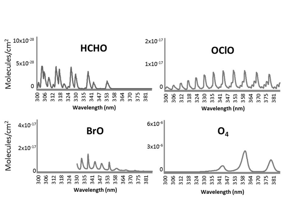
Differential optical absorption spectroscopy (DOAS) measurement of the HCHO slant columns from spectral absorption properties has been adapted to include
the correction of numerous spectral artefacts and intricately refined for each of a series of sensors of increasing spectral and spatial resolution.
Conversion of HCHO slant to HCHO vertical columns using air mass factors (AMFs) has been improved with the launch of new sensors and the incorporation of radiative transfer and chemical transport models (CTM).

The critical process of linking HCHO to BVOC emissions and filtering non-biogenic emissions to explicitly quantify biogenic emissions has also greatly improved.

This critical last step in down-scaling from global satellite coverage to local biogenic emissions now benefits from the increasing precision and near explicitness of available CTMs as well as the increasing availability of global remote-sensing data sets needed to proportionally assign the HCHO column to different related biogenic (global plant functional type and land cover classifications), atmospheric (dust, aerosols, clouds, other trace gases), climate (temperature, wind, precipitation), and anthropogenic (fire, biomass burning) factors.
